top of page


Key Features and Advantages
Through thoughtful design improvements, the upgraded system delivers enhanced flight performance and reliability, featuring a weather-resistant sealed body for light rain operations, quick-release components for easy transport, and a modular design for flexible payload integration.


Max payload 5KG
Max endurance 180min

Hybrid power system

Multi-redundant GPS

Autonomous flight beyond visual range

Multiple payload compatibility
GX-2 Hybrid power system
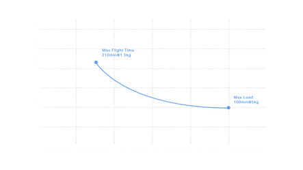
Through rigorous testing and precision engineering, the HS-332H's 5L-fuel-tank/H2-engine system achieves exceptional 54km/L efficiency (210min/150km range at 25:1 ratio), while the GX-2 hybrid power system delivers unmatched stability - together extending mission endurance and operational capabilities beyond conventional UAV platforms.


Carbon fiber fuselage and propeller
The carbon fiber fuselage and propeller are precision-engineered to optimize weight distribution and aerodynamic efficiency, ensuring maximum performance tailored to the UAV's specific operational requirements.
Intelligent Flight Control System
The advanced flight control system enables multi-rotor hovering, autonomous takeoff/landing, and BVLOS route planning, with real-time switching between auto/manual modes, precise attitude/altitude/position control, dynamic waypoint-based mission updates, redundant dual GPS/IMU architecture, external data link compatibility, and strict no-fly zone enforcement for fail-safe operations


INDUSTRY APPLICATIONS

FIRE & EMERGENCY SERVICES
Facilitate early detection of latent fire threats and critical payload delivery to inaccessible zones—improving responder safety and mission effectiveness

URBAN INFRASTRUCTURE
Automate structural inspections, detect maintenance needs, and assess construction progress - delivering real-time data to optimize asset management and extend infrastructure lifespans

SURVERYING & MAPPING
Rapid topographic mapping, real-time volumetric analysis, and high-precision cadastral surveys—transforming geospatial data acquisition with unparalleled speed and accuracy


bottom of page